|
|

Skyline Ranch: Draft Environmental Impact Report.
TR 060922 |
CUP No. 04-075 |
Oak Tree Permit No. 04-075
Prepared by: PCR Services Corporation, 233 Wilshire Blvd., Santa Monica, Calif. 90401.
July 2009.
|
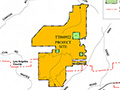
PROJECT LOCATION The Skyline Ranch site, which occupies approximately 2,173 acres, is located in the Santa Clarita Valley west of Sierra Highway, north of Highway 14 (Antelope Valley Freeway) and the City of Santa Clarita in unincorporated Los Angeles County. The project site includes 258 undeveloped parcels west of Sierra Highway between the Santa Clara River and Vasquez Canyon Road. The project site is roughly defined by Sierra Highway (Mint Canyon) on the east and southeast, residential communities in Santa Clarita on the south and southwest, Plum Canyon Road on the west, Bouquet Canyon Road to the northwest, and Vasquez Canyon Road to the northeast. PROPOSED PROJECT The project applicant proposes to develop on approximately 622 acres of the 2,173-acre site 1,260 single-family residential lots with pads ranging in size from 5,775 to 7,350 square feet, an approximately 11-acre elementary school site, approximately 12 acres of public parkland to be dedicated to the Los Angeles County Department of Parks and Recreation, and approximately 6 acres of private parkland to be maintained by a homeowners' association. Development is proposed for the southern portion of the property where slopes of 25 percent or less predominate. Nearly three quarters of the site (the northern 1,551 acres) is proposed to remain undeveloped, with approximately 1,355 acres dedicated or designated as natural open space through establishment of the proposed Skyline Ranch Conservation Area (SRCA). Approximately 166 acres of undeveloped land in the northern portion of the site on Cruzan Mesa would remain undeveloped and designated as a Non-Development/Continuing Use Area. Also, within the northern portion of the site approximately 22 acres would be preserved as a Mitigation Exchange Area for 22 acres of preserve area within adjacent recorded Tract 46018 that would be disturbed due to the construction of Skyline Ranch Road. These three areas would preserve approximately 80 percent of the lands being proposed by the County for establishment of the Cruzan Mesa Vernal Pools Significant Ecological Area (SEA). No development associated with the project would occur within proposed SEA areas. The remainder of the undeveloped northern area, approximately 9 acres, would be designated as open space. The area proposed for development would be subdivided into 1,313 lots, including 1,260 residential lots, 10 lots for park areas, 1 lot for a school site, 13 debris basin lots, 4 water tank/booster pump station lots, and 25 open space lots. Primary access to the tract is provided by the proposed extension of Whites Canyon Road from Plum Canyon to the southeast through the project interior ultimately connecting to Sierra Highway. More detailed descriptions of the various components of the project are provided in Chapter 2.0, Project Description, of this Draft EIR.
Download original pdf here.
|
Draft EIR 7/2009
EIR Addendum 12/2016
Approval Package 12/2016
Superbloom 5/2017
Approval Package 11/2017
|

The site owner makes no assertions as to ownership of any original copyrights to digitized images. However, these images are intended for Personal or Research use only. Any other kind of use, including but not limited to commercial or scholarly publication in any medium or format, public exhibition, or use online or in a web site, may be subject to additional restrictions including but not limited to the copyrights held by parties other than the site owner. USERS ARE SOLELY RESPONSIBLE for determining the existence of such rights and for obtaining any permissions and/or paying associated fees necessary for the proposed use.
