|
|
Annie Rose Briggs and the Ghosts of Castaic.
Long Beach Independent Press-Telegram | March 6, 1960.
|
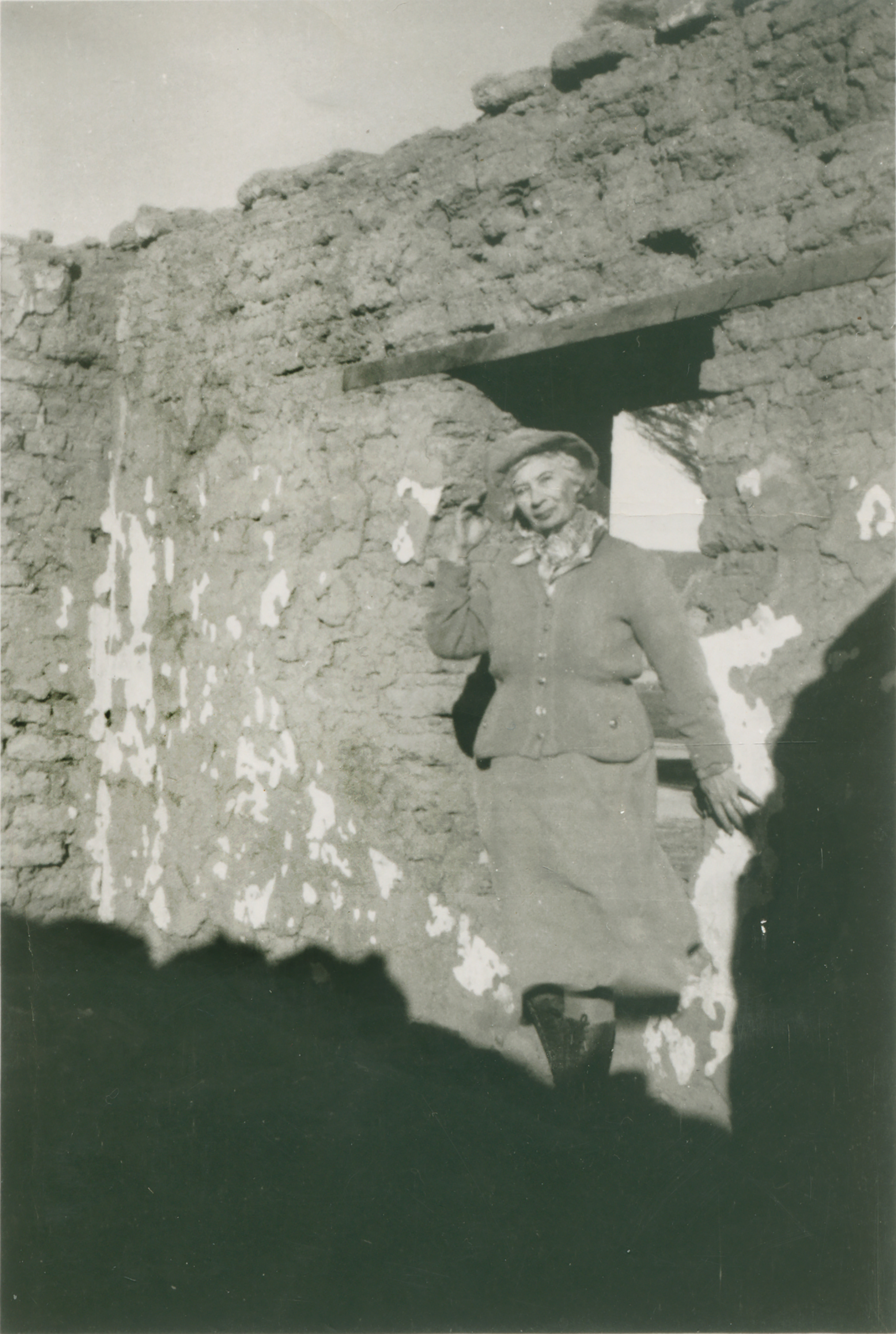
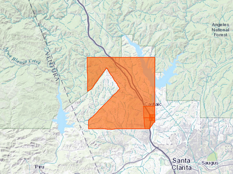
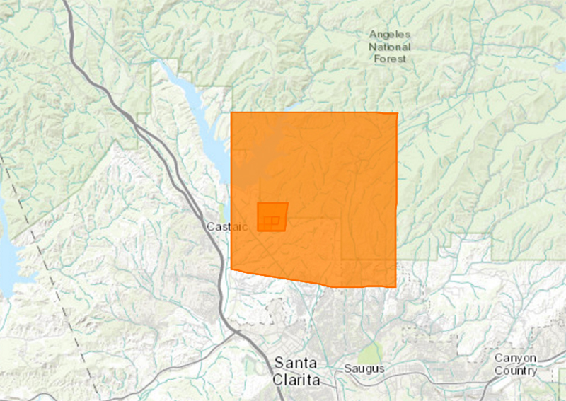
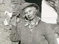
Webmaster's notes. Annie Lydia Rose Briggs (Dec. 27, 1883 - Jan. 20, 1972) stands in front of what she called the Lopez adobe in Castaic Canyon, where she said she once lived. In 1960, she would have been living at the Kelly/Knapp Ranch, farther up the Ridge Route. This photograph was probably shot at the same time, and by the same photographer, as the one that was used to illustrate the feature story below. The print was among her effects that were left to a young friend, Glenn McKinney of Newhall. Today (2017) it is in the possession of McKinney's daughter, Kathy McKinney Baxter (Hart High Class of 1971), and her husband, Jim Baxter (Hart Class of 1969). Now longtime residents of Idaho, Jim and Kathy Baxter are writing a historical novel ("The Gold of Ghost Canyon," 2017) whose main character is Annie. Regarding the story in the Long Beach Independent Press-Telegram, there are some curiosities. We're not familiar with a "Lopez adobe" in Castaic Canyon. The description, "at the fork of the old Ridge Route and the new Grapevine, or super highway 99," could place it in the vicinity of L.A. County's Castaic Sports Complex or the earlier Trueblood's Roadside Rest; see this aerial map. Darryl Manzer remembers ruins of an adobe "south of Parker Road and east of Highway 99 in the 1950s" when he lived there (pers. comm. 2017).
We know little of José Juan Lopez, reputed builder of the 1868 dwelling, but we do know that a man by that name was granted a 160-acre homestead in Castaic Canyon on July 25, 1882. (See BLM map.) This was the earliest known patent on this particular land, suggesting that the Lopez adobe was his, and bolstering the assertion that it would have been located "at the fork of the old Ridge Route and the new Grapevine." Ridge Route Communities historian Bonnie Ketterl Kane (Vol. 3:133) refers to a "Juan José Lopez" (as opposed to José Juan), whom she identifies as stepbrother to José Jesús Lopez (1853-1939), the majordomo of Gen. Edward F. Beale's Rancho El Tejon. In his memoirs as set down in Latta 1976, José Jesús Lopez (1853-1939) says Juan José Lopez was "a half-Indian raised by my father." Importantly for our story here, José Jesús Lopez was a business partner and close friend of Annie Rose Briggs' father, William B. Rose. At Latta 1976:75, José Jesús mentions Annie's mother and what is probably the adobe pictured here:
At this time [1930] Mrs. William Blackburn Rose is living at the mouth of Castaic Canyon next to an old adobe home where I once danced
for three days and nights at an old Spanish-style celebration and house warming. Then the adobe was new. It had just been completed in 1868
when this gathering took place. Mrs. Rose, my sister Luisa, and I are the last survivors of that gathering.
Annie's parents, William B. and Anna R. Rose, lived on a 160-acre homestead immediately next door to José Juan (although they weren't actually granted their land patent until Oct. 13, 1898). See BLM map. Sidebar: Next to file on José Juan's land were Robert Pogson and William George in 1901, followed by William Chormicle in 1904. The Rose family, who still lived on their homestead land until about 1919, took William Chormicle's side of the Chormicle-Jenkins feud. Mr. and Mrs. Rose's son, Annie's brother, was the Billy Rose who shot Castaic land baron William Jenkins in 1913. Jenkins survived. Back to the feature story, we don't know of a "ghost town" in Fish Canyon — which is just north of the left (western) arm of the manmade Castaic Lake Reservoir, which didn't exist in 1960. It's possible this is actually referring to the structures at the Kelly/Knapp Ranch, where Annie lived. Finally, we should point out that the translation of "Castaic" given here is twaddle. The name derives from "Kashtiq," a Ventureño Chumash word for a small body of water that has been translated as "what is like a face, or an eye." In Latta (op.cit.:108), José Jesús Lopez notes that the Spanish expression, ojo de agua (an eye, reflection of water), refers to a spring. Harrington's Chumash consultant Candelaria Valenzuela said Kashtiq meant "spring;" it may have been associated with (the real) Castaic Lake at Lebec, which is where the original Rancho Castec was located. Williamson in 1853 misspelled it "Castaic." For more on this topic, read this.
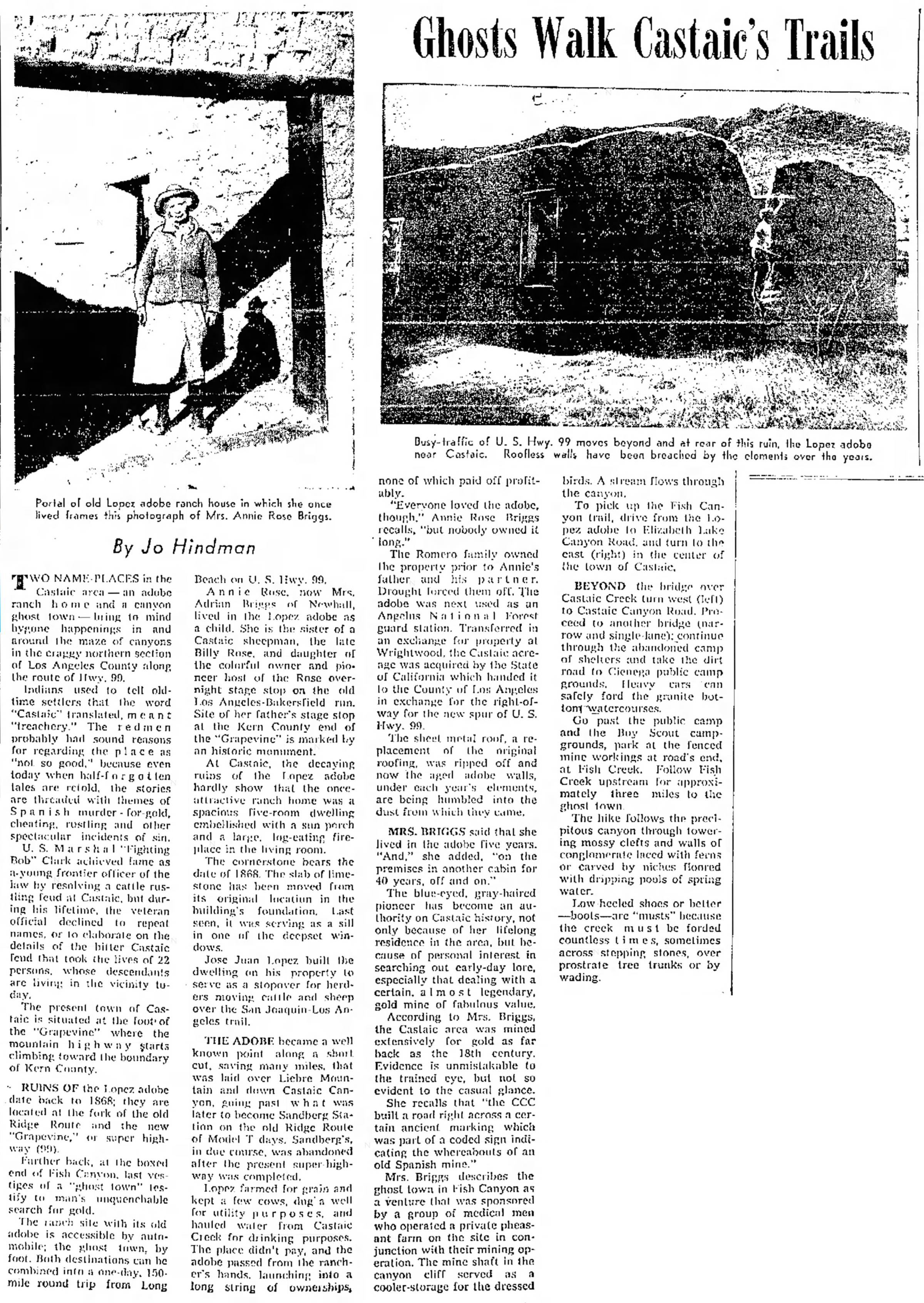
Ghosts Walk Castaic's Trails.
By Jo Hindman | Long Beach Independent Press-Telegram | March 6, 1960.
Two name-places in the Castaic area — an adobe ranch home and a canyon ghost town — bring to mind bygone happenings in and around the maze of canyons in the craggy northern section of Los Angeles County along the route of Hwy. 99. Indians used to tell old-time settlers that the word "Castaic," translated, meant "treachery." The redmen probably had sound reasons for regarding the place as "not so good," because even today when half-forgotten tales are retold, the stories are threaded with themes of Spanish murder — for gold, cheating, rustling and other spectacular incidents of sin. U.S. Marshal "Fighting Bob" Clark achieved fame as a young frontier officer of the law by resolving a cattle rustling feud at Castaic, but during his lifetime, the veteran official declined to repeat names, or to elaborate on the details of the bitter Castaic feud that took the lives of 22 persons, whose descendants are living in the vicinity today. The present town of Castaic is situated at the foot of the "Grapevine" where the mountain highway starts climbing toward the boundary of Kern County. Ruins of the Lopez adobe date back to 1868; they are located at the fork of the old Ridge Route and the new "Grapevine," or super highway (99). Farther back, at the boxed end of Fish Canyon, last vestiges of a "ghost town" testify to man's unquenchable search for gold. The ranch site with its old adobe is accessible by automobile; the ghost town, by foot. Both destinations can he combined into a one-day, 150-mile round trip from Long Beach on U.S. Hwy. 99. Annie Rose, now Mrs. Adrian Briggs of Newhall, lived in the Lopez adobe as a child. She is the sister of a Castaic sheepman, the late Billy Rose, and daughter of the colorful owner and pioneer host of the Rose overnight stage stop on the old Los Angeles-Bakersfield run. Site of her father's stage stop at the Kern County end of the "Grapevine" is marked by an historic monument. At Castaic, the decaying ruins of the Lopez adobe hardly show that the once-attractive ranch home was a spacious five-room dwelling embellished with a sun porch and a large, log-eating fireplace in the living room. The cornerstone bears the date of 1868. The slab of limestone has been moved from its original location in the building's foundation. Last seen, it was serving as a sill in one of the deepest windows. José Juan Lopez built the dwelling on his property to serve as a stopover for herders moving cattle and sheep over the San Joaquin-Los Angeles trail. The adobe became a well known point along a short cut, saving many miles, that was laid over Liebre Mountain and down Castaic Canyon, going past what was later to become Sandberg Station on the old Ridge Route of Model T days. Sandberg's, in due course, was abandoned after the present super highway was completed. Lopez farmed for grain and kept a few cows, dug a well for utility purposes, and hauled water from Castaic Creek for drinking purposes. The place didn't pay, and the adobe passed from the rancher's hands, launching into a long string of ownerships, none of which paid off profitably. "Everyone loved the adobe, though," Annie Rose Briggs recalls, "but nobody owned it long." The Romero family owned the property prior to Annie's father and his partner. Drought forced them off. The adobe was next used as an Angelus [sic] National Forest guard station. Transferred in an exchange for property at Wrightwood, the Castaic acreage was acquired by the State of California which handed it to the County of Los Angeles in exchange for the right-of-way for the new spur of U.S. Hwy. 99. The sheet metal roof, a replacement of the original roofing, was ripped off and now the aged adobe walls, under each year's elements, are being humbled into the dust from which they came. Mrs. Briggs said that she lived in the adobe five years. "And," she added, "on the premises in another cabin for 40 years, off and on." The blue-eyed, gray-haired pioneer has become an authority on Castaic history, not only because of her lifelong residence in the area, but because of personal interest in searching out early-day lore, especially that dealing with a certain, almost legendary, gold mine of fabulous value. According to Mrs. Briggs, the Castaic area was mined extensively for gold as far back as the 18th century. Evidence is unmistakable to the trained eye, but not so evident to the casual glance. She recalls that "the CCC built a road right across a certain ancient marking which was part of a coded sign indicating the whereabouts of an old Spanish mine." Mrs. Briggs describes the ghost town in Fish Canyon as a venture that was sponsored by a group of medical men who operated a private pheasant farm on the site in conjunction with their mining operation. The mine shaft in the canyon cliff served as a cooler-storage for the dressed birds. A stream flows through the canyon. To pick up the Fish Canyon trail, drive from the Lopez adobe to Elizabeth Lake Canyon Road, and turn to the east (right) in the center of the town of Castaic. Beyond the bridge over Castaic Creek turn west (left) to Castaic Canyon Road. Proceed to another bridge (narrow and single-lane); continue through the abandoned camp of shelters and take the dirt road to Cienega [sic; s/b Cienaga] public campgrounds. Heavy cars can safely ford the granite bottom watercourses. Go past the public camp and the Boy Scout campgrounds, park at the fenced mine workings at road's end, at Fish Creek. Follow Fish Creek upstream for approximately three miles to the ghost town. The hike follows the precipitous canyon through towering mossy clefts and walls of conglomerate laced with ferns or carved by niches floored with dripping pools of spring water. Low heeled shoes or better — boots — are "musts" because the creek must be forded countless times, sometimes across stepping stones, over prostrate tree trunks or by wading.
|
|

The site owner makes no assertions as to ownership of any original copyrights to digitized images. However, these images are intended for Personal or Research use only. Any other kind of use, including but not limited to commercial or scholarly publication in any medium or format, public exhibition, or use online or in a web site, may be subject to additional restrictions including but not limited to the copyrights held by parties other than the site owner. USERS ARE SOLELY RESPONSIBLE for determining the existence of such rights and for obtaining any permissions and/or paying associated fees necessary for the proposed use.
