|
|
Who Designed the Ill-Fated St. Francis Dam?
2017 World Environmental & Water Resources Conference | Sacramento, May 21-25, 2017
American Society of Civil Engineers.
|
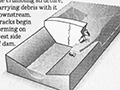
Abstract. The St. Francis Dam was built by the City of Los Angeles Bureau of Water Works and Supply (BWWS) in 1925-26 as a curved concrete gravity dam, approximately 200 feet high in San Francisquito Canyon, about 35 miles northeast of downtown Los Angeles. The reservoir provided an additional 38,000 acre-feet of storage from the Los Angeles Aqueduct. The dam failed catastrophically on March 13, 1928, killing at least 432 people, making it the most deadly American structural failure of the 20th Century. BWWS Chief Engineer and General Manager William Mulholland accepted complete blame for the failure, but who actually designed the dam has been clouded in mystery for almost 90 years. Recent research suggests that no site-specific rational design methodology was actually performed, only visual comparisons with some published cross sections of then-existing dams. More than a dozen separate investigations of the failure followed, all of which failed to ascertain the dam's actual maximum cross section or the fact that there were no stability calculations undertaken as part of the design. Recent evaluations have demonstrated that the St. Francis Dam exhibited extremely low safety factors in at least five different failure modes, including internal instability, overturning, arching, keyblock uplift, and reactivation of a megalandslide on the dam's left abutment.
Citations. Proceedings: Rogers, J. David, 2017. Who designed the ill-fated St. Francis Dam? World Environmental & Water Resources Congress 2017: pp. 379-393. Lecture: Rogers, J. David, 2017. Who designed the ill-fated St. Francis Dam? Symposium on History of California Water: California Municipal Water Development (Session HH04). Final Program, 2017 World Environmental & Water Resources Congress, Sacramento (May 23, 2017).
About J. David Rogers, Ph.D.
Dr. Rogers has 25 years of experience in evaluating the stability of natural slopes, embankments, stream channels, highways and hydraulic structures. Between 1979-2001, he managed over 500 projects in the western United States, Hawaii, Taiwan, the Philippines and the Middle East. He has served as principal investigator for scientific research funded by the National Science Foundation, U.S. Geological Survey, Federal Highway Administration, Department of Defense and the California and Missouri Departments of Transportation. Dr. Rogers has served on a number of panels, which currently include the Technical Advisory Committee on Grading Standards for the California Geological Survey, the Building Codes and Dam Safety Committees of the Association of Engineering Geologists and serves as a peer reviewer for GeoHazards Research for the National Science Foundation. Dr. Rogers is a frequent lecturer to professional and academic organizations and has taught numerous short courses for universities, including the National Short Courses on Slope Stability and Landslides and Practical Slope Restoration Methods sponsored annually by the University of Wisconsin (between 1983-92), Excavations and Grading Code Administration, Inspection and Enforcement for the International Conference of Building Officials, Association of Bay Area Governments, City of Los Angeles and Association of Engineering Geologists (from 1988-2000), Advanced Course on Slope Stability sponsored by the Federal Highway Administration (1993-94) and Identification and Mitigation of Seismic Hazards for the Southern California Earthquake Center, California Geological Survey and University of California Extension (from 1998-present). From 1994-2001 he taught undergraduate and graduate courses in engineering geology and environmental geology for planners at U.C. Berkeley, in the Departments of Civil & Environmental Engineering and Landscape Architecture and Environmental Planning. His 1992 article on the Reassessment of the St. Francis Dam Failure published by the Association of Engineering Geologists was recognized for the Rock Mechanics Award of the U.S. National Committee on Rock Mechanics and the E.B. Burwell, Jr. Award of the Geological Society of America. After publishing "A Man, a Dam and a Disaster" in 1995, his contributions to the emerging field of geoforensics were recognized by the 1996 R.H. Jahns Distinguished Lectureship in Engineering Geology Award jointly sponsored by the Association of Engineering Geologists and Geological Society of America. In 1998 he was named to the Society of Sigma Xi College of Distinguished Lecturers for the term 1999-2001. In 1994 his design of a reinforced rock cliff face on Telegraph Hill in San Francisco was recognized with the Distinguished Project Award of the Northern California Chapter of the American Public Works Association. Recently, his research efforts have been focused on developing computerized algorithms for electronic mapping of landslides using Geographical Information Systems, predictions of permanent deformation in seismically induced landslides, computerized data storage for geotechnical information, and mapping of geologic hazards using Light Detection and Ranging (LiDAR), Interferrometric Synthetic Aperture Radar (INSAR), Synthetic Aperture Radar (SAR), Side Looking Aerial Radar (SLAR)and other remote sensing techniques. Dr. Rogers is currently supervising ongoing research in landslide hazard mapping along the western margins of the upper Mississippi Embayment and New Madrid Seismic Zone, landslide mapping in the Hidu-Kush Region of west central Nepal; energy expenditure relationships for catastrophic rockslides in the Rocky Mountains; analysis of megalandslides in the Grand Canyon Region of Arizona; and development of virtual geotechnical databases through Internet portals.
|
L.A. Times 1995
Impact on American Civil Engineering (2007) VIDEO: What Led to the Failure? (2015) Who Designed the Ill-Fated Dam? (2017) Wm. Mulholland: Father of L.A.'s Water System (2017)
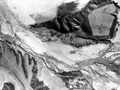
Flood Path Aerials x3
High Water Mark
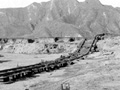
SPRR Tracks Moved
SPRR Track Erosion
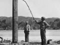
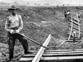
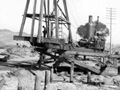
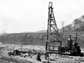
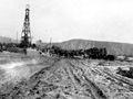
Highway Pile Driver
Highway Pile Driver
Highway Pile Driver
|
The site owner makes no assertions as to ownership of any original copyrights to digitized images. However, these images are intended for Personal or Research use only. Any other kind of use, including but not limited to commercial or scholarly publication in any medium or format, public exhibition, or use online or in a web site, may be subject to additional restrictions including but not limited to the copyrights held by parties other than the site owner. USERS ARE SOLELY RESPONSIBLE for determining the existence of such rights and for obtaining any permissions and/or paying associated fees necessary for the proposed use.
