|
|

Golden Valley Road Bridge.
Environmental Assessment.
State of California Department of Transportation and City of Santa Clarita
March 2008.
|
Note: Open as book for ease of viewing. Open original pdf to view maps and charts in their intended (landscape) orientation.
1.1 INTRODUCTION The City of Santa Clarita, with oversight from the California Department of Transportation (Caltrans), under NEPA delegation responsibilities pursuant to 23 U.S.C. 327, is proposing to construct a 1,100-foot-long Golden Valley Road bridge over the Santa Clara River. The project is located within Santa Clarita in Los Angeles County, California (Figure 1-1). The Golden Valley Road Bridge Project (Federal Project Number LA0B103) is located east of the recently extended Newhall Ranch Road and north of Soledad Canyon Road (Figure 1-2). The proposed bridge would connect Newhall Ranch Road and Soledad Canyon Road. The proposed project conforms to both the RTP and the RTIP. It is included in Destination 2030: 2004 Regional Transportation Improvement Program (RTP) Appendix I, Project Lists, on page I-31 and the Final Adopted 2006 Regional Transportation Improvement Program (RTIP) on page 32, of the Los Angeles County Local Highways Section as Santa Clarita project LA0B103 - Construct Golden Valley Road from Soledad Canyon to Newhall Ranch Road. 0 to 6 lanes. Less than 0.5 miles — includes bridge over Santa Clara River (SCAG 2006a). Both the RTP and RTIP were approved by federal agencies on October 2, 2006, and the USDOT adopted a Clean Air Act conformity determination for the RTIP on that date (USDOT 2006). The project has already received CEQA clearance as part of the Riverpark housing development, the City Council of Santa Clarita certifying the Final Environmental Impact Report (FEIR) SCH #2002091081, including the mitigation monitoring and reporting program, and adopting a statement of overriding considerations on May 24, 2005. Caltrans reviewed the FEIS and sent notice to the City on March 15, 2007, finding the document to be consistent with the proposed bridge project under assessment within this NEPA document. Caltrans concurred with the cities' level of documentation under CEQA and is responsible for NEPA determination.
1.2 PROJECT BACKGROUND
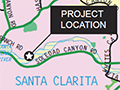
Project Location The proposed Golden Valley Road Bridge Project is located entirely within the City of Santa Clarita and would entail the construction of a bridge structure over the Santa Clara River. The bridge would connect Soledad Canyon Road and the newly extended Newhall Ranch Road (Figure 1-3). The northern terminus of the proposed action would be the easternmost extent of Newhall Ranch Road, which is currently under construction to the northwest of the project site. Grading for the majority of Newhall Ranch Road is complete and construction is anticipated to conclude between October 2007 and April 2008. The southern terminus of the proposed action would lie at the northernmost extent of the Golden Valley Road/Soledad Canyon Road interchange, which was recently completed and was opened for public access in late 2005. Construction of the Golden Valley Road bridge would take approximately 18 months. Although the majority of the surrounding land is currently vacant, the area will be developed in the future. Newhall Land Company constructed Riverpark, a residential and commercial development of over 1,000 dwelling units and 16,000 square feet of commercial space. Riverpark is located immediately northwest of the proposed bridge. Additionally, an existing mobile home park is located southwest of the project site, and utility lines run roughly north-south, parallel to the bridge alignment and separating the bridge from a mixed commercial/industrial development to the west.
Project History The trend of past growth in Santa Clarita is anticipated to continue into the foreseeable future. According to the U.S. Census Bureau, the current population of Santa Clarita is 168,253 residents. The Southern California Association of Governments (SCAG) projects that the population will increase to 231,846 by 2030. The number of households is likewise anticipated to increase from 50,887 in 2004 to 82,806 by 2030, an average annual growth rate of 2.09 percent. This compares to average annual growth rates for the County of Los Angeles and SCAG region as a whole of 1.04 and 1.40 percent, respectively (SCAG 2004). Current traffic demand in the project area meets or exceeds roadway capacity for many of the arterial roadways. Traffic demand is anticipated to increase over the next few years and a number of intersections would be expected to deteriorate to unacceptable LOS in the long term. The proposed project is the construction of a bridge structure over the Santa Clara River which is one of six components planned or under construction that would comprise, along with previously completed roadway segments, what is known as the Cross Valley Connector (CVC). The CVC is an 8.5-mile roadway through Santa Clarita that would provide a cross-town connection between Interstate 5 (I-5) and State Route 14 (SR 14). The CVC segments and their status as of August 2007 are identified below and shown in Figure 1-4.
The need for a CVC between I-5 and SR 14 has been identified in traffic studies since before the incorporation of Santa Clarita. In the 1980s, Caltrans studied the extension and realignment of SR 126 as the Cross Valley Freeway/Highway or Expressway. The Caltrans studies were the subject of much discussion between the City and various community-interest and neighborhood groups. As a result, some alignments for the road were rejected based on this public input, and the freeway concept was ultimately rejected by the City. However, the Caltrans study and other studies proved valuable over the years in determining feasible alignments across Santa Clarita for the CVC.
1.3 PROJECT PURPOSE AND NEED
Purpose The purpose of the proposed project is to reduce traffic congestion along Soledad Canyon Road and Bouquet Canyon Road as an integral component of the CVC Corridor. The project would provide an alternative east-west route through Santa Clarita, eliminating out-of-direction travel and improving interregional travel through increased east-west connectivity. The completion of the proposed bridge and the CVC project would accomplish these objectives.
Need The proposed Golden Valley Road Bridge Project is needed to complete a critical segment of the CVC Corridor, which is included in the Santa Clarita General Plan (General Plan) Circulation Element. The CVC is planned to be an arterial east-west route through the Santa Clarita Valley that would increase regional capacity by connecting I-5/SR 126 in the west to SR 14 in the east. These proposed and planned features would improve patterns of circulation, movement of people and goods, and access control in the area. They would also have an important role in relieving congestion and accommodating the rate of population and employment growth being experienced in the Valley. The current east-west routes over the Santa Clara River currently have insufficient capacity for existing and forecasted traffic. The Final Traffic Report for the Golden Valley Road and Newhall Ranch Road projects is dated May 5, 2005. The existing traffic data was analyzed and Year 2005 traffic volumes were generated. Year 2030 traffic forecasts were developed by reviewing existing and future traffic demand forecasts. Traffic performance is classified by Level of Service (LOS), designated as LOS A through LOS F and are described in Table 1-1. At signalized intersections, LOS A is defined as optimal conditions with little congestion; LOS F is defined as failure, when incoming traffic exceeds the capacity of the intersection. The City has identified LOS D or better as acceptable.
Download original pdf here.
|
SEE ALSO:
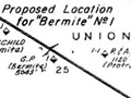
Map: Bermite No. 1 Oil Well 1958
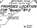
Map: Bonelli No. 2 Oil Well 1959
Gusher 1963
Cross Valley Connector / Golden Valley Bridge: Initial Assessment 2005-2006
Golden Valley Bridge Over Santa Clara River: Environmental Assessment 2008
|

The site owner makes no assertions as to ownership of any original copyrights to digitized images. However, these images are intended for Personal or Research use only. Any other kind of use, including but not limited to commercial or scholarly publication in any medium or format, public exhibition, or use online or in a web site, may be subject to additional restrictions including but not limited to the copyrights held by parties other than the site owner. USERS ARE SOLELY RESPONSIBLE for determining the existence of such rights and for obtaining any permissions and/or paying associated fees necessary for the proposed use.
