Ridge Route Highway
The Ridge Route
Click image to enlarge
| Download archival scan
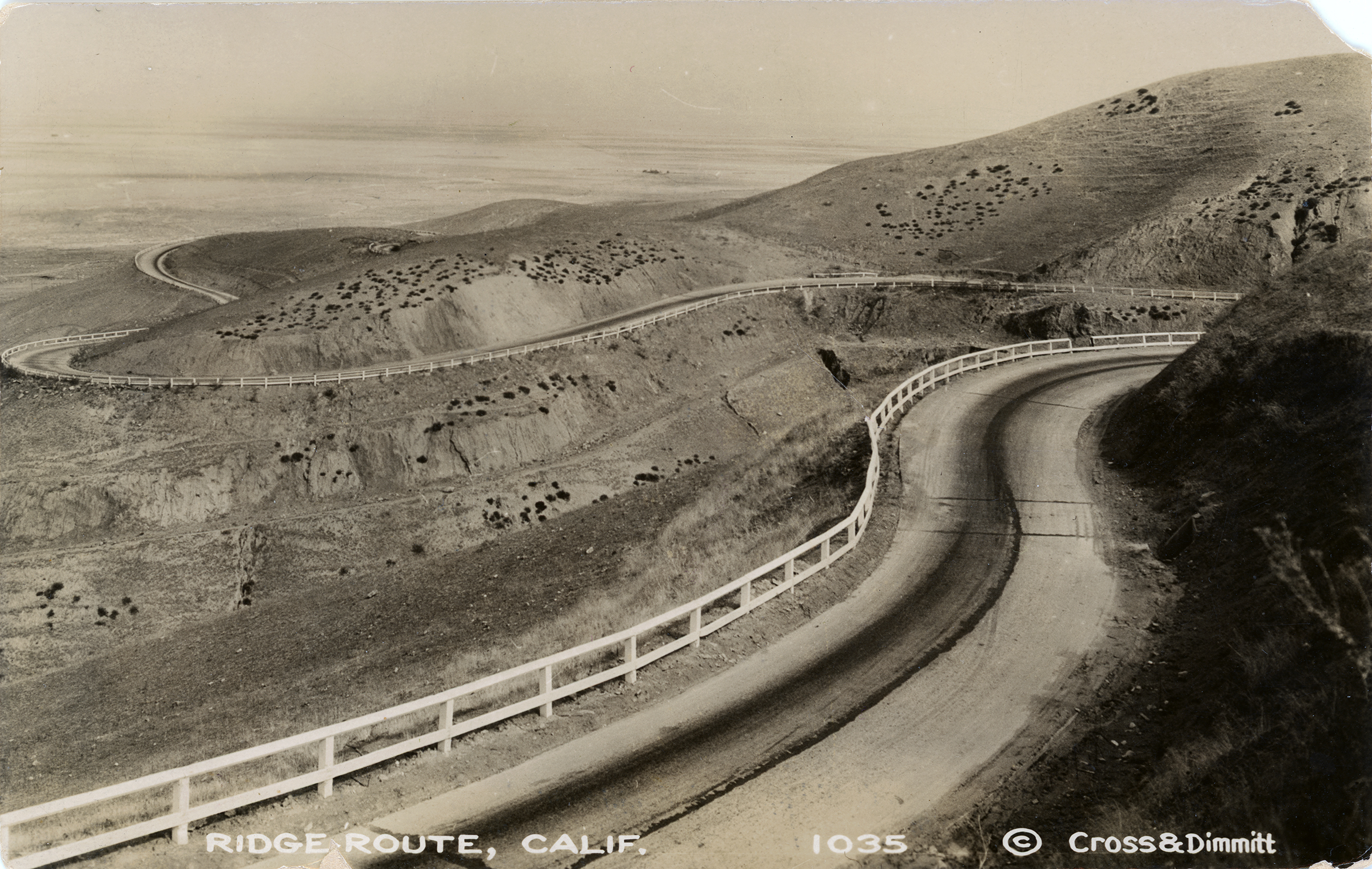
The old Ridge Route Highway looking north, opening onto the lower San Joaquin Valley at top. Gelatin print, 3½x5½ inches, published by Cross & Dimmitt as a real-photo postcard sometime between 1918 and 1930. Undivided back. We know the date from the stamp box on the back (see below): AZO with 2 arrows pointing up and 2 pointing down. This configuration was used from 1918-1930. AZO was an Eastman Kodak brand of silver chloride photographic printing paper. (Source: Philatelist and postcard dealer Ron Playle, 1937-2018, Playle's Auctions, accessed 2020). Cross & Dimmitt were Arthur B. Cross and Edward L. Dimmitt, real-photo postcard sellers in Portland, Oregon. Their photographic subjects were principally the Columbia River Gorge and other features in the Portland area, but they occasionally dropped down into California. Cross started out in Portland in 1909 when he opened his "Electric Studio" — presumably a photography studio with equipment powered by electricity. Dimmitt went to work for him in 1914, and they partnered up and changed the business name in 1916. (Source: Port Orford Historical Photos, portorfordhistoricalphotos.org, accessed 2020.)
Ridge Route history by Jerry Reynolds: Ever since the days of Phineas Banning, General Beale and the Butterfield Overland stage, vehicles made their way out of Los Angeles, through San Francisquito Canyon, down the Grapevine Pass, and then into Bakersfield. The California Highway Commission was formed in 1911, and one of its first priorities was to build a simpler, more direct road through the La Liebre Mountains. That task fell to the man with the unlikely name of W. Lewis Clark. Frustrated in several attempts to locate an easy way across the stony barrier, Clark, at last, blazed a trail right over the top from the mouth of Castaic Canyon to Gorman. It was called the Ridge Route. After a year of toil, during which four-horse Fresno scrapers graded hilltops alongside chugging Caterpillar tractors to the tune of a staggering half-million dollars, the Tejon Route, as it was originally dubbed, opened to the motoring public late in November 1915. The Auto Club did a little calculating, finding that in the 36 miles between Castaic and Gorman, there were 642 curves that added up to 97 complete circles. It did cut 60 miles off the road, however. (Note: Some sources said 642 curves, others 697.) Even before construction started in 1914, an enterprising businessman by the name of Sam Parsons purchased an acre of land from W.H. Cook fronting the stake line, then threw up a general store that catered to the needs of the workers. Afterwards, "Sam's Place" became a mecca for truckers and the beginning of a new town called Castaic.[...] While the Ridge Route did not bring permanent residents (to the Santa Clarita Valley), for the most part it did cut down on travel time to the great markets of Los Angeles. One could journey to town and back in a single day — amazing! Then there was the increasing horde of gentlemen clad in long linen dusters with goggles, piloting their chugging, spitting vehicles with names such as Marmon "41," Winton "Six," or Packard ("Ask the man who owns one"). They, their womenfolk, and children might get hungry along the way or need gasoline or automobile repairs. So began a series of what might be called "tourist traps." [...] The next stop (after Newhall-Saugus) along the Ridge Route would have been Castaic, (and then) there was the Ridge Road Garage, The Tumble Inn, Reservoir Summit, and that splendid establishment in the wilderness known as Sandberg. Local rancher Herman Sandberg provided excellent, guaranteed-fresh steaks at his hotel. Slot machines could also be found there and, in a long, low building out back (known as "The Crib,") feminine companionship was available for weary truckers and lonely salesmen. [...] In 1933 Highway 99 was carved up the canyons, bypassing the 18-year-old Ridge Route, which was already antiquated.
LW3729: 9600 dpi jpeg from original RPPC purchased 2020 by Leon Worden.
|