|
|
Prepared for: Department of Parks and Recreation, County of Los Angeles, California
By: Engineering Geology Section, Design Division, Department of County Engineer
[Report by Allan E. Seward, Principal Engineering Geologist]
Los Angeles, California | October 3, 1974
|
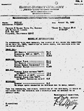
Mr. Seymour Greben, Director Attention Mr. Richard Mayer Dear Sir: Geologic Report on Oil Possibilities in the Vicinity of Placerita Canyon County Park, Los Angeles County In compliance with your request of March 20, 1974, a geologic study of potential oil production on the subject site has been completed by the Engineering Geology Section. The results are incorporated in the attached report. Very truly yours, Purpose and Scope As requested by the Los Angeles County Department of Parks and Recreation on March 20, 1974, a geologic study of potential oil production on 254 acres adjacent to Placerita Canyon County Park (see Fig. 1) in the northern portion of Los Angeles County, has been completed by the Engineering Geology Section, Department of County Engineer. The subject property is bounded on the north and east by Placerita Canyon County Park which is 5 miles east of Newhall, in the northern portion of Los Angeles County. The County has had numerous contacts with the owners of the 254 acres for possible acquisition for the existing park. It is the understanding of the Engineering Geology Section that the owners of the subject property believe that their property has appreciable petroleum potential due to the existence of abandoned oil wells on the site and the high percentage of gasoline yield obtained from an analysis of an oil sample in August 1967 by Smith-Emery Company (See Fig. 6). The source of the sample is unknown. The purpose of this geologic study was to determine the geologic structure, lithology, and history of petroleum production on the subject site and adjoining areas, and evaluate the potential for future petroleum production from the standpoint of geologic data. The scope of the study encompassed the following: 1. Library review of geologic data by others (see References). 2. Review of data held by the California Division of Oil and Gas. 3. Plotting of the subject parcel on California Division of Oil and Gas Regional Wildcat Map W1-2 Los Angeles, revised February 28, 1974. 4. Geologic reconnaissance mapping of the subject parcel using the Mint Canyon and San Fernando Quadrangles at a scale of 1:24,000. 5. Meeting at the site with Mr. Kirk Ferguson, Recreation Specialist I, to ascertain location of "old" oil wells. 6. Review of "crude oil sample #1-A, 7-16-67" analysis by Smith-Emery Company, dated August 16, 1967. 7. Review of the following aerial photographs in evaluating geologic features and locating "old" oil wells:
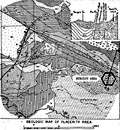
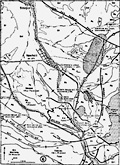
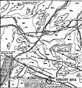
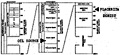
Geology The site is located on the northeastern flank of the San Gabriel Mountains at the northeast edge of the Ventura Basin. The San Gabriel Fault Zone (bearing N65°W) traverses the northern portion of the subject property and separates the Soledad Basin to the north from the Ventura Basin to the south. At the site, the Placerita Fault (southern-most branch fault with the San Gabriel fault zone) separates the basement complex on the south (a complex series of meta-sedimentary and granitic-type rocks). The basement complex is highly fractured and intricately intruded by the igneous (granitic) rock units (see Fig. 2). Within the San Gabriel Fault Zone, sandstones and shales of the Saugus, Pico, and Repetto formations overlie organic shales of Eocene age. The sediments of Eocene age are considered the source of oil occurring within the oil fields in the Newhall area. History of Oil — Newhall Area The petroleum industry in Southern California originated around natural oil seeps in the Newhall area with oil being crudely distilled and used as "burning oil" in the San Fernando Mission in 1850. The oldest oil refinery in California is located just south of Newhall and was constructed in 1876 with a capacity of 20 barrels per day. The oil was hauled to the refinery from the Pico Canyon oil field in wooden barrels. The following oil fields within the Newhall area are listed in their order of discovery (See Figures 3 and 4):
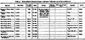
All of the above-reference oil fields are located within Miocene (Age) or Pliocene sedimentary rocks (sandstones and shales). Thus the source and reservoir traps for the oil are within the same rock units (normal occurrence). The oil occurring within the Placerita Canyon basement complex (Placerita Schist) is considered a geologic oddity and of rare occurrence. Kew (1932) published a detailed paper on this unique reservoir. The oil was formed by the natural distillation from organic material in sediments now lithified (Eocene sediments) (See Figure 7). During the migration of the oil from the source through the sediments of fine sands and clays within the San Gabriel Fault Zone, filtration has produced a clear kerosene-like high (API) 26°-38° gravity oil. This unique type of oil represents the more volatile fractions of the original oil. The high gravity oil fraction migrated from the original sedimentary rocks into the cracks and crevasses within the "Placerita schist" (crystalline rocks) along the Placerita Fault (See Figure 2). Residual amounts of gas and oil are still seeping at the ground surface and evaporating, even today. In summary, the occurrence of a high gravity oil within crystalline bedrock brought about by unusual migration routes and filtration is a unique geologic oddity. All the wildcat wells drilled within the "Placerita Schist" (basement complex) are located within Sec. 3 and 4 T3N R15W (See Figure 1). Figure 5 shows that between 1899 and 1912, eleven wells were drilled ranging from 457 to 2100 feet in depth. Seven additional wells have been drilled between 1912 and 1957 with the deepest extending to a depth of 2325 feet. All wells in this area have been abandoned, with only the first well (Freeman and Nelson White Oil Co. 1 4-3-15) producing for less than a year at a rate of 1-2½ barrels per day. The high percentage (83.3) of gasoline yield from the crude oil sample (See Figure 6) is natural since the oil in question represents the volatile fraction of the original source oil. Conclusions 1. Small amounts of kerosene-like high gravity oil occurs within the "Placerita Schist" (crystalline bedrock) of the subject property. 2. From an academic standpoint, this occurrence and type of oil (more volatile fractions of original oil) is a unique geologic occurrence. 3. The geologic structure, lithology (rock type), and history of the source of oil, inadequate reservoir potential (volume), and record of abandoned oil wells (18) are clear evidence that only minor amounts of fractional high gravity oil occurs on the subject property. 4. On the basis of this study, it is our opinion that there is no potential for economic production of petroleum on the subject property. Report by /s/ Reviewed by /s/ Aproved by [original signed] Appendix Fig. 1 [Map of subject property] Fig. 2 Geologic Map of Placerita Area Fig. 3 Location Map, Oil Fields-Newhall Area Fig. 4 Location Map, Oil Fields-Newhall Area Fig. 5 Table 4: Wells drilled in Placerita Canyon schist area (2½ miles east of Sierra Highway) Fig. 6 [Smith-Emery Company report on 1967 oil sample — below] Fig. 7 [Geological timeline] Smith-Emery Company File No.: 7675-67 Freeman & Nelson White Oil Company Report of Determinations In accordance with your request, the sample of oil which you submitted to us July 31, 1967, identified as shown above, was analyzed with the following results.
From the foregoing, and visual inspection of the residuum, it would be estimated that the material had a paraffin base as opposed to an asphalt base. Respectfully submitted, Glossary
References Brown, Arhur B. and Kew, W.S.W. (1932) "Occurrence of Oil in Metamorphic Rocks of the San Gabriel Mountains, Los Angeles County", AAPC Bull. 16, pg. [sic] 777-785. California Division Oil and Gas, (1974) "Summary of Operation" Oil Map No. 251, Rev. March 31, 1974. Campbell, Ian (1972) "Glossary of Geology", Amer. Geol. Inst. California Division Oil and Gas (1974) "Regional Wildcat Map", Map W1-2, Rev. March 31, 1974. Jennings, Charles W., and Troxel, Bennie, W., (1954), "Ventura Basin and Adjacent Areas", California Division Mines Bull. 170, Ch. 10, Geol. Guide 2. Kew, W.S.W. (1943) "Newhall Oil Field"; Geologic Formations and Economic Development of the Oil and Gas Fields of California, California Division Mines, Bull. 118, pg. 412 and 415. McLaughlin, R.P. (1914) "Petroleum Industry of California", California State Mining Bureau, Bull. 69, pg. 392. Oakeshott, Gordon B. (1950) "Geology of the Placerita Oil Field, Los Angeles County, California". California Journal Mines and Geology, Vol. 46, pp. 43-80. Oakeshott, Gordon B. (1954) "Geologic Map of Placerita Area", California Division Mines, Bull. 170, MS 31. Oakeshott, Gordon B. (1958) "Geology and Mineral Deposits of San Fernando Quadrangle, Los Angeles County, California", pp. [sic] 121. Tudor, Richard B. (1962) "Recent Developments in the Kraft-York Area of Placerita Oil Field", California Division of Oil and Gas, Summary of Operations-California Oil Fields, Vol. 48, No. 1, pp. 47-53. Uren, Lester Charles, (1953) "Petroleum Production Engineering" — Oil Field Exploitation, pp. [sic] 807. Uren, Lester Charles, (1956), "Petroleum Production Engineering" — Oil Field Development, pp. [sic] 792. Winterer, E.L. and Durham, D.L. (1962) "Geology of Southeastern Ventura Basin, Los Angeles County, California", CSPP 334-H, pg. 347. Special thanks to Mike Kaspar, Public Information Officer for the Los Angeles County Department of Public Works, for providing this report (July 10, 2012), and to Ian Swift and Ron Kraus of the Placerita Canyon Nature Center Associates for pointing us in the right direction. |
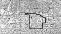
Fig. 1: Map of subject property
|
The site owner makes no assertions as to ownership of any original copyrights to digitized images. However, these images are intended for Personal or Research use only. Any other kind of use, including but not limited to commercial or scholarly publication in any medium or format, public exhibition, or use online or in a web site, may be subject to additional restrictions including but not limited to the copyrights held by parties other than the site owner. USERS ARE SOLELY RESPONSIBLE for determining the existence of such rights and for obtaining any permissions and/or paying associated fees necessary for the proposed use.
