|
|

> ROADS
> ROADS
Local Driving Routes, 1920.
Automobile Blue Book Vol. 8: California, Nevada, Utah, Arizona.
The Automobile Blue Book Publishing Co., 1920.
|
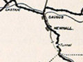
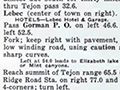
Above: Descriptions of local area driving routes (Santa Clarita Valley and environs), excerpted from the full book, which appears below. The 1920 Automobile Blue Book, Vol. 8: California, Nevada, Utah, Arizona. (Not to be confused with the later Kelley Blue Book of used car prices.) Includes a history of each area. Excerpts above: Bakersfield to Los Angeles Lebec to Elizabeth Lake Los Angeles to Bakersfield San Fernando to Ventura Saugus to Ventura Los Angeles to Mojave More
|
Origin: State Highway System
Auto Club History
El Camino Real
Florence Bailey Journal 1907
L.A. County Highways 1920
Local Driving Routes 1920
Caltrans Turns 120
4-8-2015
|

[ RETURN TO TOP ]
[ RETURN TO MAIN INDEX ]
[ PHOTO CREDITS ]
[ BIBLIOGRAPHY ]
[ BOOKS FOR SALE ]
SCVHistory.com is another service of SCVTV, a 501c3 Nonprofit • Site contents ©SCVTV
The site owner makes no assertions as to ownership of any original copyrights to digitized images. However, these images are intended for Personal or Research use only. Any other kind of use, including but not limited to commercial or scholarly publication in any medium or format, public exhibition, or use online or in a web site, may be subject to additional restrictions including but not limited to the copyrights held by parties other than the site owner. USERS ARE SOLELY RESPONSIBLE for determining the existence of such rights and for obtaining any permissions and/or paying associated fees necessary for the proposed use.
The site owner makes no assertions as to ownership of any original copyrights to digitized images. However, these images are intended for Personal or Research use only. Any other kind of use, including but not limited to commercial or scholarly publication in any medium or format, public exhibition, or use online or in a web site, may be subject to additional restrictions including but not limited to the copyrights held by parties other than the site owner. USERS ARE SOLELY RESPONSIBLE for determining the existence of such rights and for obtaining any permissions and/or paying associated fees necessary for the proposed use.
